Associazone Culturale Esplorazioni Geografiche
PALAWAN 2011 EXPEDITION PRELIMINARY REPORT
Introduction
The Saint Paul karst area and the Puerto Princesa Subterranean River have been the object of several geogprahical and caving expeditions carried out by the Italian Speleological Society (1989, 1991) and, later on, by the geographical association La Venta (2000, 2007, 2008). Some of the researchers have accompanied the project since the beginning.
During February-March 2011, La Venta has carried out another expedition, with the following aims:
- survey of the south-eastern region of the Saint Paul ridge.
- investigation of coastal cave systems (Little Underground River)
- exploration and survey of the Underground River eastern branches
- exploration and survey of the upper sector of Mount St. Paul
- exploration and survey of the Nagbituka region (northern part)
Cave Exploration
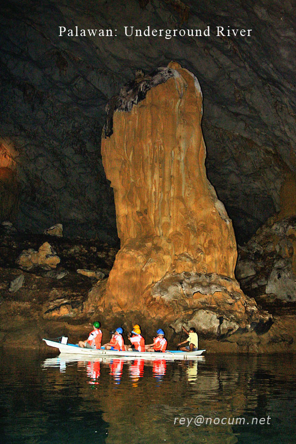
Puerto Princesa Subterranean River (PPSR)
The Puerto Princesa Subterranean River (PPSR) is composed by a main active branch (that is the underground river itself), for a total length of 8.2 kms. from the Inflow to the main entrance (Outflow), and a series of fossil (dry) upper galleries representing the ancient course of the river. The total development of the underground system, before the beginning of the expedition, summed up to 25 kms.
The exploration of a side branch discovered by the GAIA Exploration Club in 2003 has allowed the mapping of further 4.5 kms of huge galleries, named "150 Years" to recall the anniversary of the foundation of our country (1861-2011). Along these galleries, astounding calcite helictites (crystal formations) were discovered, so demonstrating that the PPSR, in spite of previous beliefs, is extremely important also from the point of view of speleothems (see Mineralogy and Speleothems).
Further exploration and mapping were carried out in other side branches of the cave, namely the Mud Galleries and the Australians' Inlet, for a total of approximately 2.5 kms.
Coastal explorations - The Little Underground River (LUR)
Northeast of the PPSR estuary, an entrance on the rocky coast gives access to a cave known since decades as the Little Underground River (LUR). The cave owes its name to its resemblance with the well-known PPSR, even if smaller in size.
The access to the cave is not easy and may be extremely dangerous in case of rough sea conditions, since the entrance is placed at the centre of a small bay, directly influenced by the waves and the tides. Due to this reason, the cave had never been seriously explored and mapped. The 2011 expeditions has led to the exploration and mapping of further 2 kms of galleries, so bringing the total development to over3 kms; the cave has not been completely explored, due to the rough sea conditions that have kept the team from further accessing the entrance.
Other cave explorations
Other caves were explored in the area of Nagbituka (North-east), in the Kwago area (South) and in the Binang Bangan massif (South-west).
Mineralogy and Speleothems
Until 2010 the PPUR was supposed to be a cave with just "normal" chemical cave deposits (speleothems and cave minerals) of local or, maybe, regional importance as a maximum. But the exploration of 2011 proved that this karst system is exceptional worldwide also from this point of view. In fact, the PPSR hosts aesthetically astonishing speleotems (like the "calcite grass", an extremely rare kind of helictites and large transparent euhedral calcite rombohedroms inside pools at the bottom of gigantic orange flowstones; both these speleothems were discovered in the new parts of the "150 Years" Galleries). In the same cave, just a few tens of meters form the fossil sirenid along God's Highway, there is also a new type of speleothem, that we named "sail", a complex type of flowstone, the evolution of which was multiphase requiring stages in which water flowed by gravity followed by stages in which capillarity ruled (this formation is still under study.)From the mineralogical point of view, the PPSR was known as hosting calcite and gypsum alone, but the first anlalyses carried out over the samples taken during the 2011 expedition evidenced that beside other minerals like strengite, iron and manganese oxides-hydroxides, the system hosts also at least one mineral new for the cavern environment: the Robertsite, a phospate related to the aggression of guano over the calcite speleothems. Another mineral new for the cavern environment seems also to be present janggunite (a very rare Manganese and Iron oxide-hydroxide).
The mineralogic studies are just at the beginning and we are confident that other cave minerals will be discovered in the PPSR
Hydrodynamics and Hydrochemistry of the PPSR
The effect of the tides inside the PPUR was already known, but in 2011 it was possible to realize a detailed bathimetric analysis of the system (from the entrance to Rockpile) in order to evaluate the amount of water present inside the system. In the meantime, automatic devices measured each 5 minutes for 6 days the level of the water, its temperature in three different sites (entrance, end of God's Highway and Rockpile). This will allow to carry out a quantitative calculation of the effect of the tides in relation with the amount of fresh water flowing inside the system: in this manner it will be possible to evaluate when the three layers of (sea, brackish, and fresh) waters will be destroyed by floods.
Water samples have been also collected their chemical content is under study.
Cave environment monitoring
During the Palawan 2011 expedition many different micro-meteorological researches were carried out. Their main purposes were:
- To characterize the global air and water fluxes inside the cave.
- To show the correlation between inflowing air fluxes and external meteorological conditions;
- To measure air thermal sedimentations inside the cave, in order to show in the future their correlation with underground ecology;
- To estimate the cave shape from airflow data;
- To estimate the cave energetic in order t measure its sensitivity to touristic visits, and their impact on the cave.
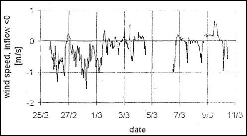
Airflow
The internal airflow is very complex, mainly controlled by external temperature, but it is possible to see also dependences from pressure and external air humidity, an effect never studied before. Typical airflows are around 50-150 m³/s. For comparison, typical air fluxes of big caves around the world are 1 - 20 m³/s. The figure shows its direction inversions and its complex time variation of short time scale.
Temperature
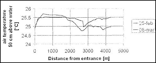
The temperature profiles along the river show a sudden drop around x-2500 (near Crocodile-Gypsum galleries) where during our operations it was always possible to observe a stationary cloud. This seems to indicate that in this region there is a colder air inflow from upper galleries, possibly connected with branches discovered during Palawan 2011. The temperature variation in 11 days is less than 0.5 ºC, unexpectedly, concentrated in the most internal parts.
Energetic
Thanks to these measures and those of water level variations, we can estimate the water and air flow in the Subterranean River main branch. The average sea water flux is around 0.8 m³/s, the flux of river fresh water is 1 m³/s, with a typical temperature difference with cave of 2 ºC. In comparison, the airflow (100 m³/s. i.e. 100kg/s) is small.
The energetic flow is then mainly hydric, and can be estimated around 15 MW, an extremely high value. It's interesting to note that also the flux from animals is significant. Both Salanganes and bats have weights around 15-20 g each and a heat production of 0.2 W; therefore each million of these flying inhabitants releases 0.2 MW.
Tourism
In order to obtain from the tourist visits, an energy flux similar to the natural one inside the cave, around 150,000 people should stay continuously inside the cave. With an average visit duration of one hour. 3,600,000 people per day have to visit the cave to release the same energy of entering fluids. One million salanganes or bats spending half a day inside the cave give an energy flux comparable with 25,000 visitors per day. To estimate the human impact on the cave, it is necessary to study in detail these fluxes, which have a time and space dependence: to do this, we have left 2 data loggers inside the cave for a better estimation of its natural variability, but it looks that the receptive capacity of Puerto Princesa Subterranean River is surely enormous, and only insane human interventions (constructions, chemical changes, tunnels...) can damage the cave. Of course, the tourist visits should never take place during salanganes and bats diplacements into and out of the cave.
The new fossil branches discovered during our operation behave probably in a completely different manner. Their thermal relation with the river conduits is not clear; nevertheless the cave temperature profiles suggest that there are connection between upper and lower conduit levels.
They are not insluated conduit because a strong airflow is present there, but its intensity and behavior have not yet been measured. From the other side, there are no water or animal fluxes, then a huge and by far more accurate and two year long-work has to be done to understand them throughly.
As a first approach, we have left another temperature data logger inside these branches, to compare their yearly temperature range with that of the river conduits below. In the next months, we hope to have some better idea of their energetic behaviour, but many further studies have to be done.
Geomorphology
During topographic surveys, many interesting morphologies have been observed and described.
The cave map itself allows us to describe the pattern of the cave recognizing the main evolutionary phases of this kart system. The new discoveries indicate a complex evolution under different condition of water flow. The interference effect between sea level changes and tectonic uplift is revealed by the presence of three main levels of cave passages.
Sea levels markers are present as water level notches at about 7.78 and 11-12 m above present sea level and as top-depositional surface of sediments. The interpretation of these markers is now in progress.
Hydrogeochemistry
During the 2011 expedition, several water samples were collected, either cave waters or surface waters. The analyses will allow to estimate the surface and underground dissolution rate.
Organic elements are also important in order to explain the role of biological processes on the formation of some cave minerals.
Geography
Despite the great access difficulties of the territory and the risks connected to covering long stretches of karst (tropical karsts like the St. Paul area are considered among the most difficult to walk and climb on), the top of St. Paul Dome was reached on March 21st 2011, by a team composed of 6 Italians, 2 park rangers and 4 local guides. The climb to Mt. St Paul Dome gave the opportunity to survey vast area south of the main massif, namely Binang Bangan, and verify the existence of other caves. The ascent to the top also revealed the presence of cave entrances that will investigated in the near future.
In the course of the expedition, several cave entrances were re-geopositioned thanks to high precision DGPS instruments. The same was done on top of St. Paul Dome, reached for the first time, with the positioning of a geodetic nail.
Topographical and geological mapping represented an integral part of the expedition acitivities.
Cartography
In the course of the expedition, several cave entrances were re-geopositioned thanks to high precision DGPS instruments. The same was done on top of St. Paul Dome, reached for the first time, with the positioning of a geodetic nail.
Topographical and geological mapping represented an integral part of the expedition acitivities.
Palawan 2011 Team Members
Antonio De Vivo, Leonardo Piccini, Alvisc Belotti, Corrado Conca, Giovanni Badino, Gaetano Boldrini, Carla Corongui, Paolo Forti, Massimo Liverani, Alessio Romeo, Natalino Russo, Francesco Sauro, Silvia Arrica, Omar Belloni, Jose Maria Calaforra, Riccardo De Luca, Jo De Waele, Luca Gandolfo, Luca Imperio, Fulvio Iorio, Valentina Malcapi, Giampaolo Mariannelli, Stefano Marighetti, Andrea Mezzetti, Daniela Pani, Siria Panichi, Michele Pazzini, Marco Taverniti, Ivy Tommasi, Sonia Zucchini
City of Puerto Princesa
Puerto Princesa Subterranean River National Park
Societa Speleologica Italiana
Club Alpino Italiano
University of Florence
University of Bologna
University of Turin
Ferrino, Dolomite, GT-Line
Mastrel, Intermatica, New Foods
Chelab, Amphibious, Korda's
The Underground River System presents such peculiar features as to make it unique within the main worldwide karst contexts. Furthermore, the fact that it is also an important show cave visited yearly by hundreds of thousands tourists increases its interest, as it works as mean to spread the scientific knowledge to the vast public; besides, it represents an example of good use of natural phenomena, allowing also the people of Palawan to live a socio-economic development respectful of the environment.
Some of the most important issues of interest of the Puerto Princesa Subterraneas River are listed as follows:
1. The Puerto Princesa Subterranean River represents on of the most important underground estuaries of the World.
La Venta - Esplorazioni Geografiche
via Priamo Tron 35F
31100 Treviso
www.laventa.it
info@laventa.it
In Presidential Proclamation No. 182, Philippine President Benigno S. Aquino III declared a National and International Promotion Campaign for the Puerto Princesa Underground River As One of the New Seven Wonders of Nature.
PPSR Park Personnel and local guides from Odjongan, Cabayugan, Kwago, Kayasan
Patronage and Sponsors
City of Puerto Princesa
Puerto Princesa Subterranean River National Park
Societa Speleologica Italiana
Club Alpino Italiano
University of Florence
University of Bologna
University of Turin
Ferrino, Dolomite, GT-Line
Mastrel, Intermatica, New Foods
Chelab, Amphibious, Korda's
Main Issues of interest of the Puerto Princesa Subterranean River
The Underground River System presents such peculiar features as to make it unique within the main worldwide karst contexts. Furthermore, the fact that it is also an important show cave visited yearly by hundreds of thousands tourists increases its interest, as it works as mean to spread the scientific knowledge to the vast public; besides, it represents an example of good use of natural phenomena, allowing also the people of Palawan to live a socio-economic development respectful of the environment.
Some of the most important issues of interest of the Puerto Princesa Subterraneas River are listed as follows:
1. The Puerto Princesa Subterranean River represents on of the most important underground estuaries of the World.
Tides affect the underground water level for more than 5 kms, and this generates the partial mixing of fresh and marine waters. Recent analyses on the system hydrodynamics and hydrochemistry have highlighted the singularity and complexity of these phenomena, allowing the Underground River to become the underground estuary world holotype.2. The Puerto Princesa Subterranean River hosts a complex and valuable karst ecosystem.
There are over 10 million salanganes (cave swallows) and bat population living in the Cave heavily contribute to the Underground River trophyc support. The marine life transported by the sea water entering the cave during the rising tide also contributes to the trophye content. Recognised troglobye, troglossen e trogophyl organisms, together with lots of animals that usually do no settle in the deepest part of a cave represent the exceptional biodiversity occurring into the Underground River Cave. Although biologic studies are still carrying on it is however already possible to state that the Underground River is one of the most complex, if not the most, karstic system in the Word.3. The Puerto Princesa Subterranean River probably is cave with a very high amount of "energy".
Its geographical location on the Thermal Equator together with the super-marine climate make this cave a relatively very warm cave and therefore with high water vapour content, but with a very limited external atmosphere temperature span. The strong air fluxes are therefore affected not only by air temperature differences and pressure, but also by wind and humidity content. The Cave, then, is not only interested by the strong fresh water river flooding and the tides, but also by strong and variable air fluxes. These fluxes, together with those generated by the oxidation processes of the organic components, contribute to the exceptional high-level energy of the cave.4. The Puerto Princesa Subterranean River contains scientifically and aesthetically unique speleothems.
The benefit of this natural context for the tourism industry is evident; the presence of this high energy content allows the cave system to drop down the effects of the high-level tourism impact.
Up to not long ago, the Puerto Princesa Subterranean River karst System was not considered interesting as regards chemical deposits. The recent surveys have highlighted that the cave bears several singular speleothems from both the morphological, aesthetic, and genetic point of view. Among them, beautiful helictites have been recently observed in the new discovered cave branches. Moreover, a mineral named Robertsite has been up-to-now found only in the Underground River karst System. Most probably, the recent samplings will lead to the discovery of new cave minerals.5. The Underground River hosts peculiar macro and micro karst morphologies.
Some karst morphologies, such as the scallops, present a strong development inside this sytem. The scientific interest of such morphologies is significant due to the chance they offer to redraw, thanks to their scaled size from bottom to top, the existing relationships between tides and speed of the fresh water flow. This kind of quantitative study has never been done in the world before. Many other morphologies of this system are peculiar, and their analysis will allow to better define the speleogenetic mechanisms active inside the system.6. The Puerto Princesa Subterranean River hosts a very well preserved fossil of a sea mammal of the Oligo-Miocene Age.
In the course of a recent La Venta exploration, the fossil of an Eocenic mammal was discovered; it is perfectly conserved and outcrops from the wall of the gallery not far from the tourist tour limit. What is exceptional about this finding is the fact that the fossil (an extremely rare thing itself) is in perfect conditions and practically totally exposed due to erosion and differential karst dissolution, that have removed the limestone and left the bones untouched due to their partial phosphate content.
Even if the issues regarding the karst system are numberless, we believe that we have here shortly listed my clearly highlight the exceptional scientific and aesthetic interest of the Puerto Princesa Subterranean River.
La Venta - Esplorazioni Geografiche
via Priamo Tron 35F
31100 Treviso
www.laventa.it
info@laventa.it
In Presidential Proclamation No. 182, Philippine President Benigno S. Aquino III declared a National and International Promotion Campaign for the Puerto Princesa Underground River As One of the New Seven Wonders of Nature.