It moves west northwest at 24kph. Here's a track of Typhoon Pablo by PAG-ASA:
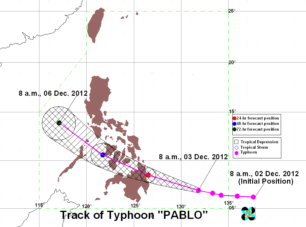
Typhoon Pablo is estimated to position at 30km East of Hinatuan, Surigao del Sur on Tuesday morning. And it will move at 150km West of Iloilo City on Wednesday morning and 400km West of Calapan City, Oriental Mindoro on Thursday morning.
PAGASA already raised three public storm signals at the following areas:
SIGNAL NO. 3 (101-185 kph winds)
- Luzon
- None
- Visayas
- None
- Mindanao
- Surigao del Sur
- Surigao del Norte
- Siargao
- Dinagat
- Agusan del Norte
- Agusan del Sur
- Davao Oriental
SIGNAL NO. 2 (61-100 kph winds)
- Luzon
- None
- Visayas
- Southern Leyte
- Bohol
- Mindanao
- Camiguin
- Misamis Oriental
- Bukidnon
- Davao del Norte
- Compostela Valley
SIGNAL NO. 1 (30-60 kph winds)
- Luzon
- Cuyo Island
- Visayas
- Eastern Samar
- Western Samar
- Leyte
- Biliran
- Aklan
- Capiz
- Antique
- Iloilo
- Guimaras
- Negros Occidental
- Negros Oriental
- Cebu
- Siquijor
- Mindanao
- Zamboanga Provinces
- Lanao Provinces
- Davao del Sur
- North Cotabato
- Maguindanao
Estimated rainfall amount is from 15 - 30 mm per hour (heavy - intense) within the 600 km diameter of the Typhoon Pablo.
December 3, 2012, 11:00 pm
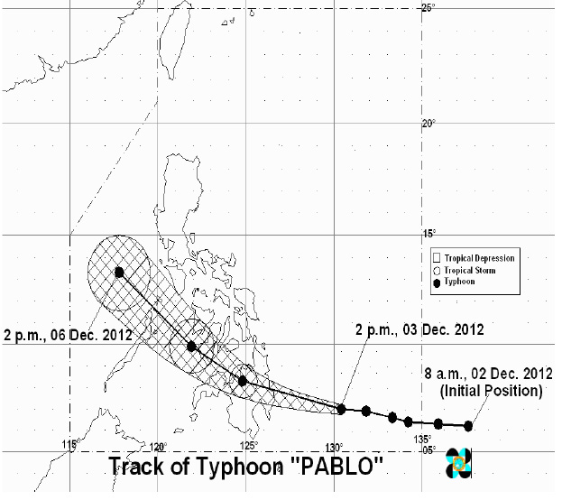
According to PAGASA, the eye of Typhoon "PABLO" was located based on satellite and surface data at 230km Southeast of Hinatuan, Surigao del Sur. It maintained its strength having maximum sustained winds of 175kph near the center and gustiness of up to 210kph. It will move West at 26kph and is expected to be in the vicinity of Bacolod City by tomorrow evening. By Wednesday evening, it will be at 180km Northwest of Puerto Princesa City and at 670km West of Metro Manila by Thursday Evening.
Track of Typhoon Pablo
PAGASA raises storm signal on the following areas:
| Public Storm Warning Signal | Luzon | Visayas | Mindanao |
| Signal No. 3 (winds of 101 - 185 kph is expected in at least 18 hrs) | --- | --- |
|
| Signal No. 2 (Winds of 61 - 100 kph is expected in at least 24 hours) |
|
| |
| Signal No. 1 (Winds of 45 - 60 kph is expected within the next 36 hours) |
|
|
|
December 4, 2012, 5:00 am
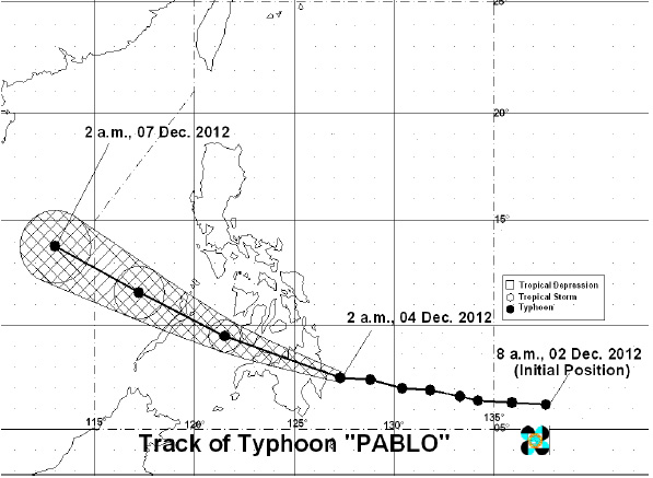
Typhoon Pablo has made landfall over Baganga, Davao Oriental. At 4:00am today, the eye of Typhoon Pablo was located based on satellite and surface data at 40km East of the eastern coast of Davao Oriental. It is still maintaining its strength with maximum sustained winds of 175kph near the center and gustiness of up to 210kph. It will move West at 26kph. It is expected to be at 180km Southwest of Roxas City by tomorrow morning. By Thursday morning, it will be at 230km Northwest of Puerto Princesa City and at 780km West of Metro Manila by Friday morning.
| Public Storm Warning Signal | Luzon | Visayas | Mindanao |
| Signal No. 3 (winds of 101 - 185 kph is expected in at least 18 hrs) | --- |
|
|
| Signal No. 2 (Winds of 61 - 100 kph is expected in at least 24 hours) |
|
| |
| Signal No. 1 (Winds of 45 - 60 kph is expected within the next 36 hours) |
|
|
|
Track of Typhoon Pablo
December 5, 2012, 5:00 am
According to PAGASA, at 4:00am today, the center of Typhoon Pablo was located based on satellite and surface data at 180km East of Puerto Princesa City. It further weakened and has maximum sustained winds of 130kph near the center and gustiness of up to 160kph. It is estimated to move West Northwest at 24kph.
It is expected to be at 440km Northwest of Puerto Princesa City by tomorrow morning and by Friday morning, it will be at 780km West of Calapan, Oriental Mindoro
PAGASA raises public storm warning signals at the following areas:
| Storm Signal | Luzon | Visayas | Mindanao |
| Signal No. 3 |
| None | None |
| Signal No. 2 | Rest of Palawan |
| |
| Signal No. 1 |
|
|
|
Residents living in low lying and mountainous areas under public storm warning signals are alerted against possible flashfloods and landslides. Likewise, those living in coastal areas under public storm warning signal #3 and signal #2 are alerted against big waves or storm surges generated by this Typhoon Pablo.
Fishing boats and other small seacrafts are advised not to venture out into the Eastern Seaboards of Visayas and Mindanao.
Damages and Casualties Brought By Typhoon Pablo
Are you prepared for this strong Typhoon Pablo? Share to us your preparation tips in the comment below.
- https://www.affordablecebu.com/